Category:Photos and videos from unmanned aerial vehicles of Germany
Jump to navigation
Jump to search
Countries of Europe: Bosnia and Herzegovina · Italy · North Macedonia · Russia‡ · Spain‡ · Ukraine
‡: partly located in Europe
‡: partly located in Europe
Media in category "Photos and videos from unmanned aerial vehicles of Germany"
The following 64 files are in this category, out of 64 total.
-
 Aerial image of Lützensömmern.jpg 1,920 × 1,080; 1.98 MB
-
 AFG-Werne-Drohnenbild.jpg 1,600 × 900; 584 KB
-
 Alexanderkirche Dezember 2021.jpg 2,048 × 1,536; 681 KB
-
 Biotop Seewiesen Luft.jpg 4,048 × 2,699; 8.82 MB
-
 Bodennebel Panorama.jpg 8,192 × 2,608; 5.53 MB
-
 Burgruine Kürnberg aus fogel sigcht.jpg 2,560 × 1,440; 2.32 MB
-
 Cologne at Night – 360° panorama from high up – July 2021.jpg 8,192 × 4,096; 8.97 MB
-
 Cologne Cathedral at Night – 360° panorama from high up – June 2021.jpg 8,192 × 4,096; 7.98 MB
-
 Cologne centre with the Cathedral at night – 360° panorama from high up – July 2021.jpg 8,192 × 4,096; 3.28 MB
-
 Drohnenaufnahme Villa Haas (Sinn).jpg 1,600 × 900; 251 KB
-
 Ebelsbach Luftaufnahme 2017 – Blick nach Westen.jpg 1,920 × 1,011; 494 KB
-
 Ebelsbach Luftaufnahme 2017 – Blick von Norden.jpg 1,920 × 1,014; 839 KB
-
 Ebelsbach Luftaufnahme 2017 – das Schloss Rotenhan.jpg 1,920 × 1,017; 639 KB
-
 Ebelsbach Luftaufnahme 2017 – der ehemalige Judenhof.jpg 1,920 × 1,014; 649 KB
-
 Ebelsbach Luftaufnahme 2017 – die Kirche.jpg 1,131 × 828; 301 KB
-
 Efferen 360° Panorama.jpg 10,000 × 5,000; 7.12 MB
-
 Efferen 360° Panorama.png 20,480 × 10,240; 118.2 MB
-
 Eichensee luft.jpg 4,048 × 3,032; 11.44 MB
-
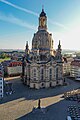 Frauenkirche Dresden 2024 Luftbild Toni Klemm 2500px.jpg 1,667 × 2,500; 1.45 MB
-
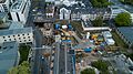
 Frauenkirche und Neumarkt Dresden bei Nacht 2024 Luftbild Toni Klemm 2500px.jpg 2,500 × 1,667; 1.23 MB
-
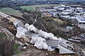 HaarbachtalbrueckeGesprengt 14-56-56.jpg 2,768 × 1,827; 2.86 MB
-
 HaarbachtalbrueckeGesprengt 14-57-34.jpg 3,486 × 1,906; 2.9 MB
-
 Haßfurt von Norden (2017).jpg 3,840 × 2,160; 849 KB
-
 Historisches Archiv Einsturzstelle 2017.jpg 3,954 × 2,221; 1.32 MB
-
 Hochkirch Pommritz Pulverhaus Aerial alt2.jpg 4,000 × 2,250; 7.7 MB
-
 Kalscheurer See - Köln - 2017.jpeg 3,840 × 2,160; 1.91 MB
-
 Kalscheurer Weiher – Kugelpanorama.jpg 5,376 × 2,688; 2.04 MB
-
 Klettenbergpark Köln von oben - 2017.jpg 3,000 × 1,480; 1.33 MB
-
 Klettenbergpark-Rosengarten-2017.jpg 1,660 × 1,487; 825 KB
-
 Klettergarten Stetten Luftbild.jpg 3,517 × 2,634; 8.56 MB
-
 Köln Klettenberg – Kugelpanorama aus großer Höhe (2018).jpg 5,376 × 2,688; 1.85 MB
-
 Köln Luftbild 360° südlich vom Zentrum – Dezember 2018.jpg 6,144 × 3,072; 3.78 MB
-
 Köln Luftbild 360° südlich vom Zentrum.jpg 6,144 × 3,072; 4.09 MB
-
 Köln Ossendorf West und Bocklemünd – 360°-Luftbild.jpg 8,192 × 4,096; 13.25 MB
-
 Köln Südstadt 360 Drohnenpanorama Winter 2019.jpg 8,192 × 4,096; 3.86 MB
-
Köln von oben – Amtsgericht, Unicenter, Historisches Archiv – Sept. 2020.webm 2 min 37 s, 3,840 × 2,160; 65.48 MB
-
Köln Waidmarkt von oben - 23. März 2019.webm 30 s, 1,920 × 1,080; 79.88 MB
-
 Köln Weiden Neubaugebiet 2018.jpg 1,649 × 522; 201 KB
-
 Köln Zollstock West - Luftbild 360° - März 2019.jpg 8,192 × 4,096; 6.68 MB
-
 Köln Östlich.jpg 3,992 × 2,242; 917 KB
-
 Linow (Rheinsberg, Brandenburg) – 360°-Panorama von oben (2019).jpg 2,732 × 1,366; 643 KB
-
 Luftaufnahme der Rieselfelder mit Blick gen Osten über die Havel.jpg 2,310 × 1,520; 2.59 MB
-
 Luftaufnahme der Rieselfelder mit Blick gen Westen.jpg 2,289 × 1,520; 2.66 MB
-
-
 Luftbild vom Fühlinger See in Köln, Deutschland (48331263331).jpg 5,464 × 3,070; 12.1 MB
-
 ND Feuchtgebiet im Gewann Mauswiesen.jpg 5,828 × 3,885; 12.42 MB
-
 ND Talabschnitt der Rems zwischen Weinstadt und Remshalden samt Fuß des Kappelberges.jpg 10,365 × 6,910; 32.25 MB
-
 Neuer Friedhof Stetten.jpg 4,048 × 3,032; 10.63 MB
-
 Neukirchen bei Neuss – Luftaufnahme von Nordosten.jpg 3,849 × 2,885; 1.72 MB
-
 Otto Maigler See – Little Planet 180° Panorama.jpg 3,685 × 3,666; 998 KB
-
 Otto-Maigler-See - Kugelprojektion (Panorama).jpg 5,000 × 1,308; 756 KB
-
 Prerow, Kugelpanorama aus großer Höhe, 2018.jpg 5,376 × 2,688; 2.77 MB
-
 Rommelshausen Luftbild Sportpunkt & Altersheim.jpg 4,048 × 3,032; 8.14 MB
-
 Rügen - 50188208128.jpg 5,464 × 3,640; 11.43 MB
-
 Rügen22.jpg 5,464 × 3,640; 12.21 MB
-
 Schleuse Diemitz und die umliegenden Seen – 360° Panorama aus der Luft – Juli 2021.jpg 27,328 × 13,664; 22.42 MB
-
 Schloss stetten Luftbild.jpg 4,868 × 3,245; 9.68 MB
-
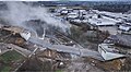
 SE DD Bildergalerie Klaerwerk Kaditz Faulung.jpg 2,192 × 1,233; 1.87 MB
-
Severinsbrücke Köln – Video aus 50 m Höhe – Oktober 2021.webm 2 min 35 s, 3,840 × 2,160; 55.55 MB
-
 Spreepark Berlin by my Drone (Unsplash).jpg 3,823 × 2,859; 6.16 MB
-
 Spreepark Berlin by my Drone 1 (Unsplash).jpg 3,592 × 2,692; 5.02 MB
-
 St. Johann Baptist – Köln (Dez. 2017 von oben).jpg 3,992 × 2,992; 1.79 MB
-
 Wohnplatz Seemühle Luft.jpg 4,048 × 3,032; 9.89 MB
-
 Wurmlingen (Rottenburg) Luftbild.jpg 10,521 × 4,499; 25.57 MB


.jpg)


.jpg)


.jpg)


_%E2%80%93_360%C2%B0-Panorama_von_oben_(2019).jpg)


.jpg)
.jpg)


.jpg)
.jpg)
.jpg)

_Luftbild.jpg)
.jpg)